Ares to Cent Converter
- Last formula update:
Decimal & Rounding Policy
- Calculations use full available precision internally to keep the Ares to Cent conversion accurate.
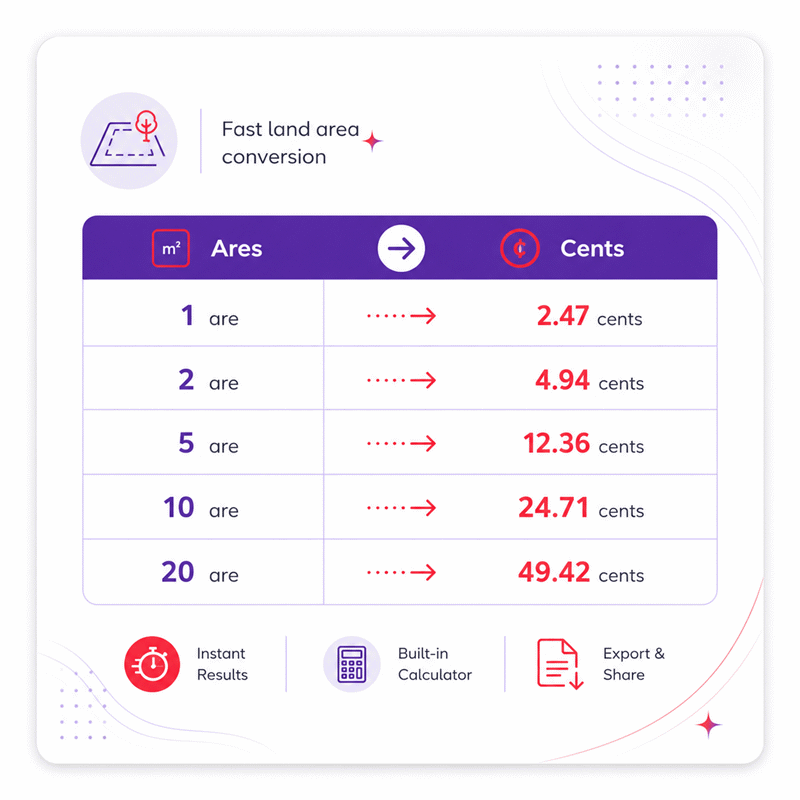
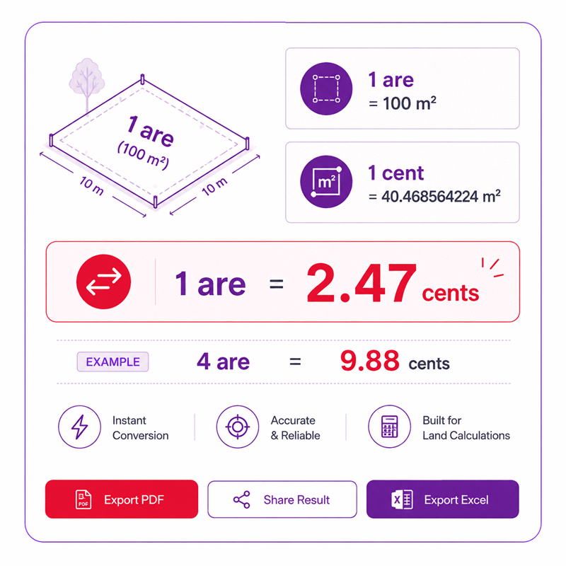
- For easy reading, converted cent values may be displayed to two decimal places, such as 1 are = 2.47 cents.
- Reverse conversions may use additional decimal places when needed, such as 1 cent = 0.404686 ares.
- Rounding is applied only to the displayed result and never to intermediate calculations.
- Trailing zeros may be omitted so results remain clear, compact, and easy to read.
Valid range
- Ares: Enter any positive finite area value greater than 0; the calculator converts it to cents using the fixed area conversion relationship.
- Cents: Enter any positive finite area value greater than 0; the calculator converts it back to ares using the inverse conversion relationship.
- Zero, negative values, non-numeric entries, and non-finite numbers are outside the valid input range.
- Very large values are accepted only when the resulting calculation remains within the calculator’s supported numerical range.

Felovyn Quarnwick
Reviewers:
Meravie Quellmont
Herixon Vosswick
Check our editorial policy
September 6, 2026
1.0.0
Initial calculator and formula release.
Our engineers are here to help you get it right.
How Does the Ares to Cent Converter Help You Check Land Area Quickly?
Ares to Cent Converter gives you a fast, clear way to compare land area without changing the physical size of the property. It supports both forward and reverse conversion, so you can work from ares or cents depending on the source record.
- Use the original land record and confirm its unit before converting.
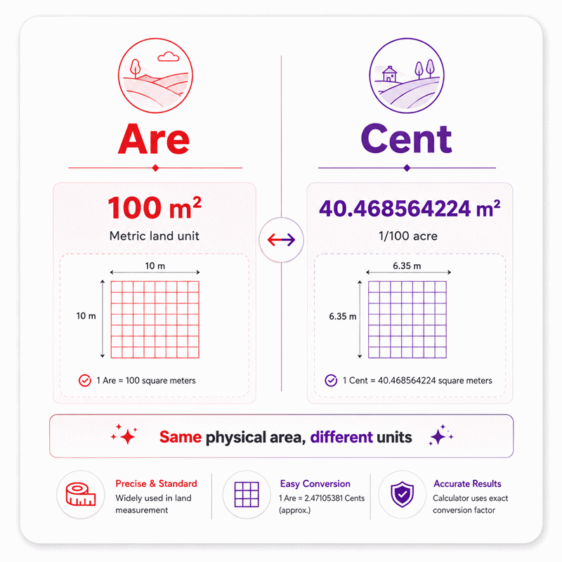
- One are represents 100 square meters of area.
- One cent represents 40.468564224 square meters of area.
- The same land can be expressed in ares, cents, or other compatible area units.
- Plot shape does not change the conversion once total area is known.
- Reverse conversion is useful when property records start with cents instead of ares.
- Always keep the original measurement beside the converted result for easier verification.
- Do not confuse cent with centiare, because they are different area units.
- Use a common unit before comparing property size or price between listings.
- A converted area does not replace an official survey, boundary record, or legal document.
The Ares to Cent Converter is most useful for property review, land records, agriculture, planning, surveying, and quick cross-checks between different measurement systems.
Assumptions used in this calculator
- The converter assumes standard international definitions for ares and cents.
- One are is treated as exactly 100 square meters.
- One cent is treated as exactly 40.468564224 square meters.
- Both units represent the same underlying physical area.
- Conversions assume no local variation in land measurement definitions.
- All calculations use full numerical precision before display rounding.
- Displayed decimals may be rounded without changing the internal calculation.
- Input values are assumed to represent valid positive finite areas.
- Negative, zero, infinite, and non-numeric values are considered invalid.
- No surveying corrections, boundary adjustments, or legal tolerances are applied.
- Results do not replace certified land surveys or official measurements.
- Legal land records should be verified with the relevant authority.
- Professional verification is recommended for industrial, contractual, or high-value applications.
Results are rounded for display.
Internal calculations use full precision.
Formulas Used in Ares to Cent Converter :
Area Unit Basis
These fixed area definitions provide the common physical basis for the conversion.
Bidirectional Ares to Cents Conversion
- A = area measured in ares.
- C = area measured in cents.
The same physical-area relationship is used in both directions. Internal calculations retain full precision, and rounding is applied only when a result is displayed.
Variables & Definitions
View a complete list of all variables used in this calculator, including definitions and units
Ares to Cent Converter Variables and Units
| Symbol | Variable | Description | Unit | Calculation Role |
|---|---|---|---|---|
| A | Area in Ares | The land or surface area expressed in ares. | are | Used as the input or calculated result when converting between ares and cents. |
| C | Area in Cents | The same physical area expressed in cents. | cent | Used as the input or calculated result when converting between cents and ares. |
Unit Conversion Table
Unit Conversion Table
Unit Conversion Table
Unit Conversion Table
Unit Conversion Table
Unit Conversion Table
Example Calculation
The calculation first treats the input as an area measured in ares. Each are represents exactly 100 square meters in the conversion basis. The equivalent cent value is found using 40.468564224 square meters per cent. Full precision is retained during calculation, while the displayed result is rounded for readability.
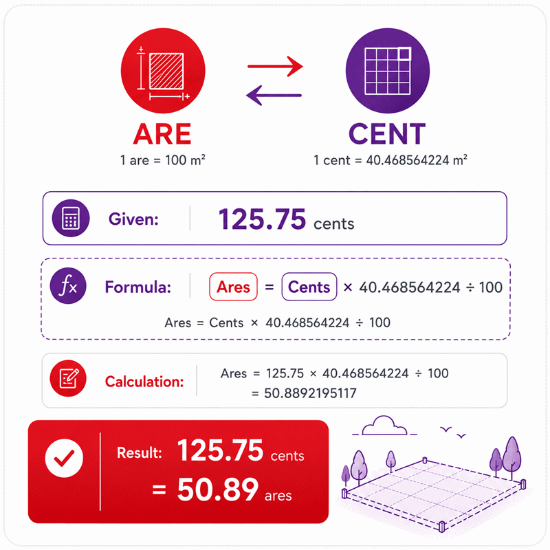
In reverse solving, the known cent value is used to calculate the equivalent area in ares. Each cent represents 40.468564224 square meters, while each are represents 100 square meters. The calculator preserves full precision during the conversion to avoid cumulative rounding errors. The final displayed value may be rounded for clearer reading without changing the internal result.
Results are rounded for display.
Internal calculations use full precision.
Calculations Disclaimer
Before You Convert Land Area, Confirm What the Record Actually Means
A land record can look simple and still cause a costly mistake. The Ares to Cent Converter helps remove that first layer of uncertainty. The Ares to Cent Converter works best when the source unit is clear. Before entering any number, check how the original area was recorded. Do not guess the unit from context alone. Property documents may use several land units on one page.
An are and a cent both measure area. However, they are not the same unit. This matters when land values affect ownership, planning, or sale decisions. A small reading mistake can change every later calculation. The safest habit is simple. Read the unit first, then read the number.
Why Land Records Can Cause Confusion Even When Numbers Look Simple
Land records often combine older and newer measurement systems. One document may use metric units. Another may use regional land units. A third may show both. This creates a common trap. Users sometimes copy the correct number with the wrong unit.
Another problem involves similar unit names. A cent and a centiare are different area units. Their similar names can mislead new users. Never treat them as interchangeable. The source document should clearly identify the intended land unit.
Plot shape creates another source of confusion. A long plot can equal a square plot. Both can have the same area. Unit conversion does not depend on plot shape. The total measured area is what matters. Length, width, and boundary shape matter during surveying. They are not needed after the final area is known.
Three-second check: identify the unit before you trust the number.
A Quick Check Before You Trust Any Converted Figure
Keep the original document beside the converted result. Compare the property name, plot reference, and recorded unit. Then confirm that the copied value matches the source. This simple step prevents many avoidable errors.
If the document comes from another person, confirm its measurement system. Do the same with spreadsheets and survey exports. Never assume two files use the same area unit.
A converted number should support a land decision, not replace its source. Keep both values together during review. This makes later checks much easier. It also helps another person understand how the result was obtained.
For important property work, treat the converter as a calculation tool. Legal boundaries still come from official records and qualified survey work. This separation protects the user from false confidence.
Are vs Cent: A Small Unit Difference Can Change a Large Land Decision
Property buyers often compare two plots without normalizing their units first. That can make the smaller plot appear larger. The problem becomes worse when price is involved. A price per are cannot be compared directly with a price per cent. Both listings must first use the same area unit.
An are belongs to the metric area system. It is useful for land and property measurement. A cent is widely used in regional land measurement. It remains familiar in many property discussions. The practical difference is not only mathematical. Each unit also appears in different local workflows.
Where Are and Cent Measurements Matter Most
Ares can appear in surveys, cadastral records, planning documents, and property files. Cents often appear in residential land discussions and regional property records. They can also appear in agricultural transactions. Knowing both units helps users compare documents from different systems.
A property buyer may receive a survey in ares. The seller may discuss the same plot in cents. A lender may use square meters in another document. These three descriptions can refer to the same land. A reliable workflow keeps that relationship clear.
Agricultural users face the same issue. Farm records may use one unit. Contractors may quote another unit. Planning teams may prefer metric area. Converting the same land into a common unit prevents communication errors.
LAND RECORD → IDENTIFY UNIT → ENTER AREA → COMPARE RESULT → VERIFY SOURCE
Why Comparing Land Before Converting It Can Mislead You
Imagine two listings with different area units. The numbers alone tell you very little. A larger number does not always mean a larger property. The unit gives the number meaning.
This is especially important when comparing price per unit. Buyers should first standardize the land area. Then they can compare price, location, access, and development value. That creates a fairer decision process.
Sellers also benefit from this approach. A clear area conversion reduces repeated buyer questions. It can make a listing easier to understand. It also helps prevent disputes caused by unit confusion.
The same rule applies to reports and spreadsheets. Never sort land records by area without checking their units. Mixed units can produce a completely false ranking. Convert first. Compare second.
Use the Converter as a Decision Tool, Not Just a Number Box
A common mistake is converting an area and stopping there. The number is useful, but the surrounding decision matters more. A good land workflow asks what the converted area will support. The answer may affect a purchase, survey, plan, or agricultural task.
AxiCalculator can make that workflow faster. Users can enter the known land area and review the related value. The process also works in the opposite direction. This is useful when different people use different land units.
Better Workflows for Property, Survey, and Agricultural Decisions
Property buyers can use the converter during listing comparisons. They can place several plots into the same unit. This makes the size difference easier to understand. Price comparisons then become more meaningful.
Survey teams may receive data from several systems. A survey drawing might use metric area. A local property record might use cents. Converting both into a common unit can expose transcription mistakes. It also makes review faster.
GIS users can follow a similar process. Mapping software often reports area in metric units. A local client may expect a regional land unit. Converting the measured area helps bridge that communication gap.
Sloping land deserves extra attention. The unit conversion itself does not change. However, surface area and horizontal map area can differ. Users should confirm which area the survey provides. This is a measurement issue, not a unit issue.
Red flag: a correct conversion cannot repair an incorrect source measurement.
Why Reverse Solving Makes Real Work Faster
Land discussions do not always start with ares. A buyer may receive cents first. A planner may need the equivalent metric area. A reverse-capable tool removes an unnecessary manual step.
This matters during live conversations. Users can answer questions without rebuilding the calculation. They can move between the two land units quickly. That reduces friction during property review.
Reverse use is also helpful during document checks. A user can start with one reported unit. Then the converted value can be compared with another document. Large differences can signal a copy error or unit mismatch.
The key idea is simple. The physical land does not change. Only its numerical description changes. A useful calculator should support that workflow in either direction.
Common Mistakes That Make a Correct Land Conversion Look Wrong
A surprising number of conversion disputes begin outside the calculator. The tool receives the wrong value or wrong unit. It then produces a mathematically valid result. The user sees an unexpected number and assumes the calculator failed.
The first mistake is unit confusion. Cent and centiare are easy to confuse. Are and acre can also be misread. Their names look related, but their meanings differ. Always copy the complete unit name with the number.
Mistakes Hidden Inside Property Documents and Spreadsheets
Spreadsheet errors are especially common during bulk land reviews. One column may contain several unit types. Another person may assume every row uses the same unit. The final comparison then becomes unreliable.
Decimal separators can cause another problem. Some files use a period. Others use a comma. A value may also be copied with thousands separators. Check the number before entering it into any tool.
Old reports can create hidden conflicts. A newer survey may replace an earlier measurement. If both remain in a project folder, users may convert the wrong figure. Always check document dates and revision status.
Manual retyping also creates risk. A single missing digit can change a property decision. Copy values carefully. Then compare the entered number with the original record.
Another mistake appears during price analysis. Area conversion and land valuation are separate tasks. A larger converted area does not reveal market value. Location, zoning, access, demand, and land condition still matter.
How to Catch a Bad Input Before It Becomes a Bad Decision
Use a short verification chain. First, confirm the property reference. Second, confirm the area unit. Third, confirm the copied number. Finally, compare the converted result with related documents.
SOURCE DOCUMENT → UNIT CHECK → VALUE CHECK → CONVERT → CROSS-CHECK → DECISION
If two records disagree, do not average them. Find the reason first. One record may use another unit. One may contain an older survey. One may include a transcription error.
Keep screenshots or exported results with project notes when useful. This supports later review. It also reduces repeated calculations between team members.
Decision rule: keep the original measurement beside every converted value.
For contracts or boundary disputes, use professional verification. A converter supports calculation. It does not certify ownership or physical boundaries.
A Practical Workflow for Safer Land-Area Decisions
The most useful conversion is one that improves the next decision. Start with the original land record. Keep its unit visible. Then use AxiCalculator to translate the area into the unit you need. Do not remove the original value from your notes.
This simple habit creates a clear audit trail. Another person can understand the source. They can also review the converted figure without guessing. That matters in property teams and shared projects.
For Property Buyers and Sellers
Buyers should convert competing listings into one common unit. This makes size comparisons easier. Then compare the price on the same area basis. Only after that should other property factors be reviewed.
Sellers can use the same method before publishing a listing. Showing familiar area units can reduce buyer confusion. However, the official recorded measurement should remain clear. Marketing language should never replace legal property information.
When a broker sends a value by message, compare it with documentation. Do not rely on memory or verbal descriptions alone. A simple unit check can expose a large mismatch quickly.
AxiCalculator also supports faster communication between people using different land units. A buyer can work in ares. A seller can work in cents. Both can discuss the same physical land without manual conversion.
For Survey, Farm, and Planning Teams
Technical teams should keep source measurements unchanged in master records. Converted values can appear in separate fields. This prevents the converted result from replacing the original survey data.
Farm managers can use a common unit when comparing plots. This helps with planning, allocation, and contractor communication. It also reduces confusion when local records use another land unit.
Planning teams should document which area each value represents. Horizontal plan area may differ from measured surface area. This detail matters on uneven land. The conversion unit cannot solve that measurement question.
Shared links and exported results can improve teamwork. They help another person reproduce the same review. A clear digital record also reduces repeated data entry.
When a result affects a major decision, verify it independently. Compare it with the original document and related records. For legal or boundary matters, use qualified local professionals.
AxiCalculator is most useful when speed and clarity work together. The tool can remove routine conversion effort. The user can then focus on the real decision. That may involve buying, selling, planning, surveying, or managing land.
Use the converter before comparing land from different records. Keep the source value beside the result. Share the calculation when another person needs to review it. A simple, traceable workflow creates more confidence than an isolated number.
Frequently Asked Questions
Which area value should I convert when a listing and official record show different figures?
Can I use the converter when my original land measurement is in square meters?
What is the best way to save and share a land conversion for later review?
What should I do when the converted result differs from a broker’s figure?
How should I manage mixed area units in a large engineering spreadsheet?
At what stage should Are-to-Cent conversion occur in a GIS or cadastral workflow?
How should an engineer document an Are-to-Cent conversion for reproducible project records?
Our engineers are here to help you get it right.