Acreage Calculator
- Last formula update:
Decimal & Rounding Policy
- All acreage calculations use full internal precision, and intermediate values are not rounded.
- Displayed results are rounded only for readability while preserving enough decimal places for accurate land-area conversions.
- Trailing zeros are removed automatically, so results remain clear and easy to read.
- Very small or very large values may use scientific notation when standard decimal formatting becomes impractical.
- Unit changes are calculated from the unrounded base value to prevent cumulative rounding errors.
Valid range
- Width: Enter a finite value greater than 0, with a supported converted length of up to 1e150 meters.
- Length: Enter a finite value greater than 0, with a supported converted length of up to 1e150 meters.
- Area: Enter a finite value greater than 0, with a supported converted area of up to 1e300 square meters.
- Unit Price: When used, enter a finite value greater than 0 and no greater than 1e300.
- Total Price: When used, enter a finite value greater than 0 and no greater than 1e300.
- Calculation requires the area directly or any two values among Width, Length, and Area; the missing value is calculated automatically.

Felovyn Quarnwick
Reviewers:
Meravie Quellmont
Herixon Vosswick
Check our editorial policy
September 6, 2026
1.0.0
Initial calculator and formula release.
Our engineers are here to help you get it right.
What Can the Acreage Calculator Tell You About Your Land?
Acreage Calculator turns land measurements into a clear area result for property planning, comparison, farming, and real estate decisions. Enter the width and length of a rectangular parcel, or use a known area when that information is already available. The calculator can also work backward to find a missing width or length when enough information is provided.
- Calculate rectangular land area from width and length.
- Convert land measurements between acres, hectares, square feet, square yards, and square meters.
- Use different supported measurement units without changing the physical land size.
- Find a missing land dimension through reverse solving.
- Compare properties using acreage and price per unit area.
- Estimate total land cost from acreage and unit price.
- Identify possible conflicts between listed acreage and measured dimensions.
- Use known area directly when rectangular dimensions are unavailable.
The Acreage Calculator is most useful when the source measurements describe the same parcel accurately. Irregular, angled, or curved boundaries may require verified area data instead of simple width and length. For property purchases, construction near boundaries, or legal decisions, calculated acreage should be checked against reliable property records and professional survey information.
Assumptions used in this calculator
- The land parcel is treated as a measurable two-dimensional surface.
- Width and length represent perpendicular dimensions of a rectangular plot.
- Entered measurements are assumed accurate and taken with suitable instruments.
- All selected units are assumed dimensionally compatible with their corresponding fields.
- Unit conversions use fixed standard conversion factors without intermediate rounding.
- Area is calculated from width and length when both are available.
- Reverse calculations assume the provided values describe the same land parcel.
- Irregular boundaries require an equivalent measured area rather than rectangular dimensions.
- Elevation, slope, terrain curvature, and surface relief are not included.
- Legal property boundaries must be verified using certified survey documentation.
- Pricing assumes a constant unit price across the entire calculated area.
- Taxes, fees, grading costs, and regional adjustments are excluded.
- Displayed rounding does not alter the calculator’s full-precision internal calculations.
Results are rounded for display.
Internal calculations use full precision.
Formulas Used in Acreage Calculator :
1. Compatible Unit Conversion
This relationship converts a length or area from its selected source unit to any dimensionally compatible target unit before or after the acreage calculation.
2. Rectangular Land Area
Width and length are first expressed in meters with the unit-conversion relationship above. The same area relationship is algebraically solved for the single missing dimension during reverse calculation, so separate equivalent reverse formulas are not duplicated.
3. Total Price
The calculated area is converted to the area unit selected for pricing before the unit price is applied. The same relationship is used in reverse when total price is entered instead of unit price.
4. Result Display Rounding
Calculations retain full internal floating-point precision. Rounding is applied only when a value is displayed, using up to 12 significant digits so unit conversions do not accumulate intermediate rounding errors.
Variable Definitions
- Qs: quantity expressed in the selected source unit.
- Qt: the same physical quantity expressed in the target unit.
- ks: source-unit factor relative to the applicable SI base unit.
- kt: target-unit factor relative to the applicable SI base unit.
- Wm: plot width expressed in meters.
- Lm: plot length expressed in meters.
- Am2: calculated or converted plot area expressed in square meters.
- Ap: calculated area expressed in the area unit selected for pricing.
- p: price per selected unit of area.
- C: total price for the calculated area.
- x: full-precision numerical result before display formatting.
- xdisplay: result shown to the user after display rounding.
- roundSig: rounding operation to the specified number of significant digits.
| Quantity | Unit | Symbol | SI Conversion Factor |
|---|---|---|---|
| Length | Millimeter | mm | 0.001 m |
| Length | Centimeter | cm | 0.01 m |
| Length | Meter | m | 1 m |
| Length | Kilometer | km | 1000 m |
| Length | Inch | in | 0.0254 m |
| Length | Foot | ft | 0.3048 m |
| Length | Yard | yd | 0.9144 m |
| Length | Mile | mi | 1609.344 m |
| Length | Nautical mile | nmi | 1852 m |
| Area | Square millimeter | mm² | 0.000001 m² |
| Area | Square centimeter | cm² | 0.0001 m² |
| Area | Square meter | m² | 1 m² |
| Area | Are | a | 100 m² |
| Area | Hectare | ha | 10000 m² |
| Area | Square kilometer | km² | 1000000 m² |
| Area | Square foot | ft² | 0.09290304 m² |
| Area | Square yard | yd² | 0.83612736 m² |
| Area | Acre | ac | 4046.8564224 m² |
| Area | Square mile | mi² | 2589988.110336 m² |
| Area | Square nautical mile | nmi² | 3429904 m² |
Variables & Definitions
View a complete list of all variables used in this calculator, including definitions and units
Acreage Calculator Variables and Calculation Parameters
| Variable | Meaning | Unit or Type | Calculation Role |
|---|---|---|---|
| Qs | Quantity expressed in the selected source unit. | Compatible length or area unit | Starting quantity used during unit conversion. |
| Qt | The same physical quantity expressed in the target unit. | Compatible length or area unit | Converted quantity produced from the selected source value. |
| ks | Conversion factor of the source unit relative to the applicable SI base unit. | Conversion factor | Converts the source quantity to the internal SI reference value. |
| kt | Conversion factor of the target unit relative to the applicable SI base unit. | Conversion factor | Converts the internal SI value to the requested target unit. |
| Wm | Land or plot width expressed in meters. | m | Used with length to calculate rectangular land area and can also be solved in reverse. |
| Lm | Land or plot length expressed in meters. | m | Used with width to calculate rectangular land area and can also be solved in reverse. |
| Am2 | Calculated or converted land area expressed in square meters. | m² | Internal base-area value used for acreage conversion, reverse solving, and result generation. |
| Ap | Calculated land area expressed in the area unit selected for pricing. | Selected area unit | Provides the area quantity multiplied by the unit price. |
| p | Price per selected unit of land area. | Currency per area unit | Used with the priced area to calculate total cost and can be solved from total price. |
| C | Total price for the calculated land area. | Currency | Final pricing result or reverse-calculation input for unit price. |
| x | Full-precision numerical result before display formatting. | Calculated numeric value | Preserves internal precision before any display-only rounding is applied. |
| xdisplay | Numerical result shown to the user after display rounding. | Formatted numeric value | Provides a readable result without changing the underlying calculation value. |
| roundSig | Significant-digit rounding operation used for result display. | Rounding function | Formats displayed values to the calculator's supported significant-digit precision. |
Unit Conversion Table
Acreage Calculator Unit Conversion Table
| Unit Group | Unit Name | Symbol | Equivalent in SI Base Unit | Used For |
|---|---|---|---|---|
| Scientific Units | Millimeter | mm | 0.001 m | Very small dimensions and precise length conversions |
| Scientific Units | Centimeter | cm | 0.01 m | Small dimensions and metric measurement conversions |
| Scientific Units | Meter | m | 1 m | Standard metric width and length measurements |
| Scientific Units | Kilometer | km | 1000 m | Large land dimensions and extensive properties |
| Popular Units | Inch | in | 0.0254 m | Small imperial dimensions and detailed measurements |
| Popular Units | Foot | ft | 0.3048 m | Property boundaries and common land dimensions |
| Popular Units | Yard | yd | 0.9144 m | Residential plots, fields, and land dimensions |
| Popular Units | Mile | mi | 1609.344 m | Very large properties and regional distances |
| Scientific Units | Nautical Mile | nmi | 1852 m | Specialized geographic and coastal measurements |
| Scientific Units | Square Millimeter | mm² | 0.000001 m² | Very small area values and precise conversions |
| Scientific Units | Square Centimeter | cm² | 0.0001 m² | Small metric area measurements |
| Scientific Units | Square Meter | m² | 1 m² | Standard SI land area and internal conversions |
| Scientific Units | Are | a | 100 m² | Metric land parcels and agricultural areas |
| Popular Units | Hectare | ha | 10000 m² | Agricultural land and large metric properties |
| Scientific Units | Square Kilometer | km² | 1000000 m² | Large territories, estates, and regional areas |
| Popular Units | Square Foot | ft² | 0.09290304 m² | Residential lots and imperial property areas |
| Popular Units | Square Yard | yd² | 0.83612736 m² | Gardens, yards, plots, and land areas |
| Popular Units | Acre | ac | 4046.8564224 m² | Farmland, real estate, property acreage, and land planning |
| Popular Units | Square Mile | mi² | 2589988.110336 m² | Large land holdings and regional property areas |
| Scientific Units | Square Nautical Mile | nmi² | 3429904 m² | Specialized coastal, marine, and geographic areas |
Example Calculation
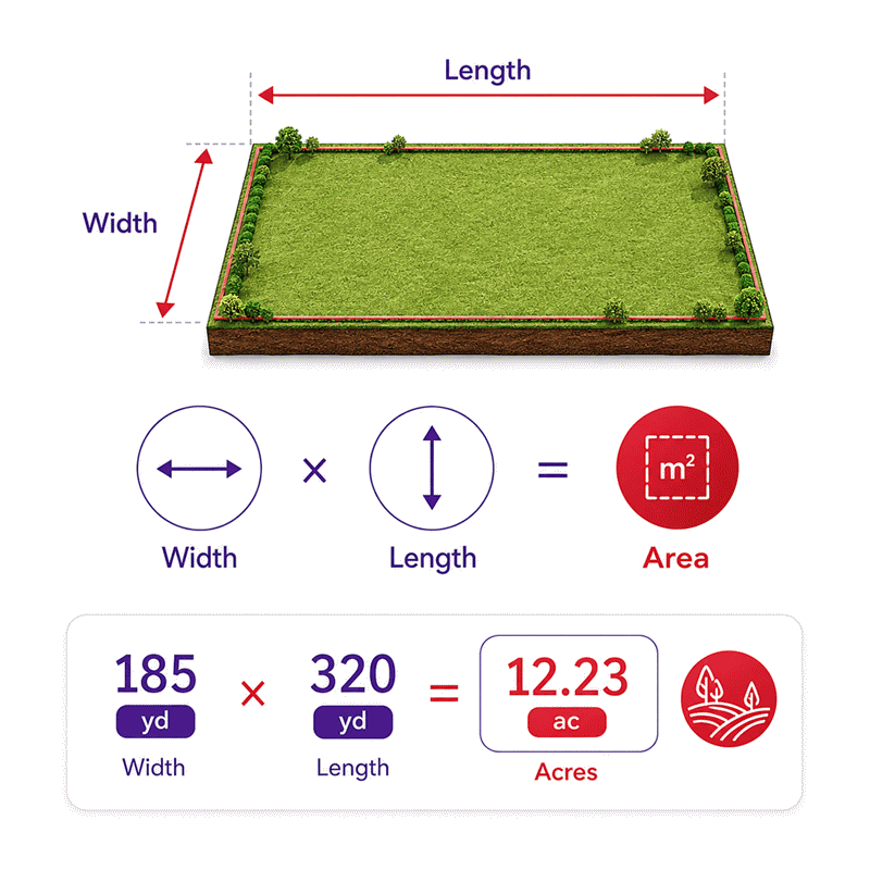
A = 185 yd × 320 yd
A = 59,200 yd²
A = 59,200 × 0.83612736 = 49,498.739712 m²
A = 49,498.739712 ÷ 4,046.8564224 = 12.2314049587 ac
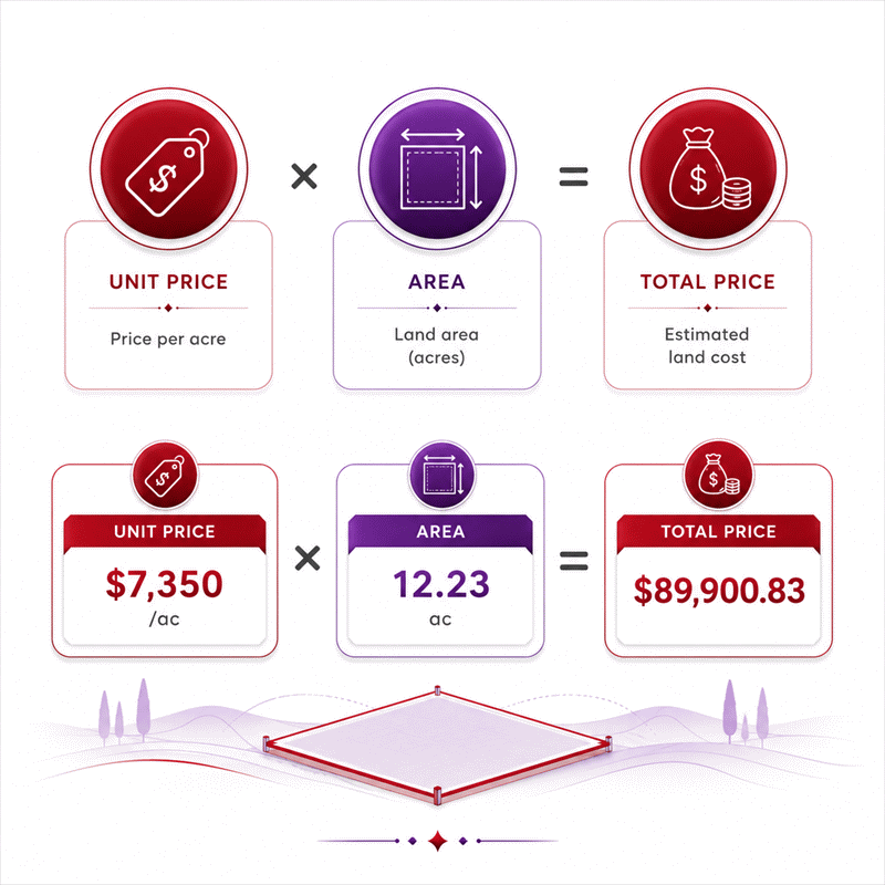
C = $7,350 × 12.2314049587
C = $89,900.8264463
A rectangular parcel measuring 185 yards by 320 yards covers 59,200 square yards. The calculator converts this area to its internal square-meter value before generating equivalent area units. The resulting parcel area is approximately 12.2314 acres or 4.94987 hectares. With a unit price of $7,350 per acre, the calculated total price is approximately $89,900.83.
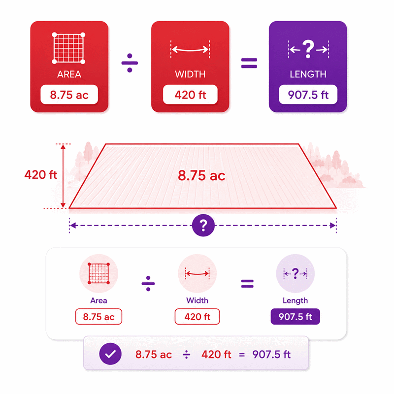
Aft2 = 381,150 ft²
L = 381,150 ft² 420 ft
L = 907.5 ft
In this reverse calculation, the land area and width are known while the length is unknown. The acreage is first converted to square feet so the area and width use compatible units. Dividing 381,150 square feet by a width of 420 feet gives a length of 907.5 feet. The solved length can then be converted to other supported length units without changing the physical dimension.
Results are rounded for display.
Internal calculations use full precision.
Calculations Disclaimer
How Does an Acreage Calculator Work?
Land measurements often arrive in different units and incomplete combinations. An acreage calculator turns those values into one clear land-area result. AxiCalculator can work with width, length, or a known area. It also supports reverse solving when one dimension is missing.
The process starts with the measurements you already know. Width and length describe a rectangular parcel. A known area can also act as the starting value. The calculator then keeps every value linked to the same physical land area.
This matters because land records rarely use one universal unit. A listing may show acres. A survey may show feet. A site plan may use meters. The calculator keeps those measurements connected without changing the actual parcel size.
The Problem: Property Measurements Rarely Arrive in One Clean Format
A buyer may receive width in feet and length in yards. Another listing may provide only total acreage. A farm record may use hectares instead. These differences make quick comparisons harder than they should be.
A reliable acreage calculator removes that friction. It lets users work with the units already available. The result can then be viewed in more useful land-area units.
This is especially helpful during early property research. You can test dimensions before requesting a formal survey. You can also compare parcels using the same area reference.
What the Calculator Can Solve
The calculator handles more than one simple direction. Width and length can produce the total area. Area and width can reveal the missing length. Area and length can reveal the missing width.
This two-way behavior saves time during property analysis. You do not need separate tools for each missing value. The same calculation model stays active across the entire form.
It also helps when a seller provides incomplete dimensions. You can test whether the available values make practical sense. Large differences may reveal a measurement or listing issue.
Why Reverse Solving Matters in Real Property Work
Real property data is often incomplete. A parcel description may include acreage and frontage only. Reverse solving gives you a useful estimate for the missing depth.
The result can support early planning and comparison. It can also expose impossible or suspicious combinations quickly. That makes reverse solving valuable before deeper technical review.
How to Calculate Acreage from Length and Width
The most common problem is simple. You know the parcel width and length. You need the total acreage.
For a rectangular parcel, both dimensions describe the complete shape. The calculator first relates those dimensions to one common measurement system. It then determines the full land area.
This workflow prevents confusion between linear measurements and area measurements. Feet describe distance. Square feet describe area. Acres also describe area, not length.
That distinction seems small, but it prevents major errors. A long parcel can still contain very little acreage. A wider parcel may contain the same acreage with less depth.
Calculating Acreage When Measurements Are Given in Feet
Feet are common in property listings and boundary descriptions. They are also easy to misunderstand. Two linear values must first describe the rectangular surface.
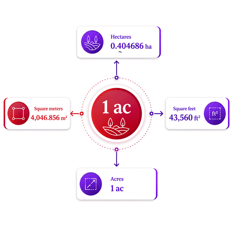
Once the area exists in square feet, it can be expressed in acres. One acre represents 43,560 square feet. This reference makes feet-based property calculations practical and easy to compare.
Suppose two properties have the same acreage. Their dimensions can still look completely different. One parcel may be narrow and deep. Another may be wide and shallow.
That is why acreage should not be treated as a fixed shape. It represents area only. The parcel geometry remains a separate issue.
Calculating Acreage When Measurements Use Yards or Meters
Yards often appear in informal land measurements. Meters are common in metric property records. Both can be used without changing the calculation concept.
The calculator preserves the physical measurement during unit changes. Only the displayed number changes. This makes mixed measurement sources easier to manage.
Using meters can also simplify technical planning. Many engineering and mapping systems use metric units. Acreage can still remain the final result for property comparison.
The best practice is simple. Enter the measurements exactly as they were recorded. Then select the correct unit for each value.
Why the Acreage Result May Look Smaller Than Expected
Large dimensions do not always create a large acre value. This often surprises first-time land buyers. Acres cover a much larger area than one square foot.
A parcel with thousands of square feet may still remain below one acre. This is normal. The important point is the total surface area.
Never judge acreage from one dimension alone. Width can look impressive while depth remains short. Both dimensions must describe the complete rectangular parcel.
Reverse Acreage Calculation: Solve for a Missing Land Dimension
A common real estate problem starts with missing information. The acreage is known, but one parcel dimension is missing. Reverse solving can estimate that missing dimension.
This method is useful for rectangular land. It works when the known area and one dimension describe the same parcel. The remaining dimension can then be determined.
This feature is useful during listing reviews and early feasibility checks. It can also help estimate frontage or depth before field verification.
How to Find Length When Acreage and Width Are Known
Imagine a listing that provides acreage and parcel width. The depth is missing. This can make site planning difficult.
The known acreage first represents the total parcel area. The known width provides one side of the rectangle. The missing length completes the geometry.
The solved value gives a practical depth estimate. It can support layout studies and early land comparisons. It should still match the actual boundary shape.
This method becomes especially useful for farms and large residential parcels. Many listings provide frontage but omit full depth information.
How to Find Width When Acreage and Length Are Known
The opposite problem is also common. A property may have known acreage and depth. Frontage or width may be missing.
Reverse solving can estimate the width from those known values. This provides a fast way to test parcel proportions. It can also expose obvious data conflicts.
For example, a very small calculated width may affect practical access. A very large width may suggest incorrect source dimensions. These clues help guide further review.
When Reverse Solving Can Become Misleading
Reverse solving assumes the parcel behaves like a rectangle. Real land may contain angled or curved boundaries. Some parcels also include several connected sections.
In those cases, one calculated width may not represent every boundary. The result can still support screening. It should not replace boundary-specific measurements.
Price Per Acre and Total Land Cost Calculations
Two properties can share the same asking price but offer different acreage. Total price alone can hide that difference. Price per acre creates a clearer comparison.
AxiCalculator can connect land area with a selected unit price. This helps buyers compare larger and smaller parcels on the same basis.
The pricing section should be treated separately from physical measurement. Acreage describes land size. Price per acre describes the financial relationship to that size.
How to Calculate Total Land Price from Acreage and Unit Price
A buyer may know the acreage and market price per acre. The missing value is the total land cost. This is a common planning task.
The calculated area is first expressed in the pricing unit. The unit price can then apply to that land quantity. The resulting value represents the land-based total.
This can help during farmland analysis and development screening. It can also support quick comparisons between several listings.
Keep added project costs separate from the land price. Roads, utilities, taxes, grading, and permits can change total investment.
How to Calculate Price Per Acre from Total Property Cost
A listing may show one total price without a unit rate. That makes comparison harder. Price per acre provides a useful second view.
Once total acreage is known, the total price can be spread across that area. This reveals how much each acre effectively costs.
The result can expose large differences between similar properties. A cheaper total price may still mean a higher price per acre.
That insight is useful during shortlisting. It creates a common basis before deeper property evaluation.
What Price Per Acre Does Not Reveal
Price per acre is useful, but it cannot describe land quality. Two equal parcels can have very different practical value.
Access, zoning, utilities, slope, soil, drainage, and location still matter. Easements and environmental limits may also affect usable land.
Use price per acre as one decision layer. Do not use it as the complete buying decision.
Acreage Calculation Accuracy in Real Property Decisions
A precise calculator cannot repair poor source measurements. This is one of the most important acreage lessons. The result depends on the measurements entered.
A width measured roughly from a map can contain error. A rounded listing dimension can also change the final area. Larger parcels can magnify those differences.
The calculator is most useful when source measurements are reliable. Better inputs create more meaningful results.
How Measurement Errors Affect the Final Acreage Result
Area depends on more than one dimension. An error in width affects the total area. An error in length does the same.
If both dimensions contain error, the final difference may become larger. This matters during property valuation and site planning.
Small residential lots may tolerate tiny estimation differences during screening. Large commercial parcels may require tighter measurement control.
The practical rule is simple. Match the measurement quality to the decision risk.
Why Map, Listing, and Field Measurements May Disagree
A map can show one value while a property listing shows another. A field measurement may produce a third result. This does not always mean fraud.
Sources may use different measurement methods. Some may also use rounded dimensions. Older records can contain simplified boundary descriptions.
Irregular parcels create another source of disagreement. A listing may report legal acreage instead of rectangular dimensions. Those values should not be forced into perfect geometry.
When a Professional Land Survey Becomes the Better Choice
High-risk decisions need stronger evidence than a quick estimate. Legal boundaries are the clearest example. Construction near property lines also increases risk.
A professional survey can identify actual corners and boundary geometry. It can also reveal conditions that simple dimensions cannot show.
Use the calculator for analysis, planning, and comparison. Use professional boundary data when the decision requires legal certainty.
Common Acreage Calculation Mistakes and How to Avoid Them
Many acreage errors begin before any calculation happens. Users often mix distance and area units. Others assume every parcel is rectangular.
One frequent mistake involves perimeter. Perimeter measures the distance around a parcel. It does not directly provide the land area.
Another mistake comes from using rounded dimensions. A listing may show 200 feet instead of 198.7 feet. That small difference can change the acreage result.
Mixed units can also create large errors during manual calculations. Width may be entered in feet while length remains in yards. The values must represent compatible physical measurements.
Users sometimes confuse total acreage with usable acreage. A parcel can contain ten acres but offer less usable space. Roads, setbacks, slopes, or protected areas can reduce practical use.
Another common mistake involves shape. A diagonal property line changes the actual surface. Multiplying maximum width by maximum length can overstate the parcel area.
Property buyers should also avoid visual guessing. A parcel may appear large because it is long. Another may feel small because it is compact.
The safer approach uses measured dimensions and verified area data. A calculator can then organize those values consistently.
Rectangular and Irregular Land Require Different Thinking
A straight rectangular lot is easy to describe. Irregular land is not. This difference can change the meaning of every dimension entered.
Rectangular acreage uses one width and one length for the whole parcel. Irregular land may have several widths and changing boundary angles.
This does not make the acreage unknowable. It simply requires better boundary information. The total area may already exist in property records.
Why One Width and One Length Cannot Describe Every Parcel
Consider a triangular corner cut from a rectangular lot. Maximum width and length still describe the outer limits. They no longer describe the true occupied area.
Curved boundaries create the same issue. So do parcels beside roads, rivers, or angled property lines.
If a verified area value exists, enter that area directly. This avoids pretending the parcel has rectangular dimensions.
If only rough dimensions exist, treat the result as an early estimate. That distinction protects better planning decisions.
How to Approach Complex Land Before Making a Decision
Start by identifying the parcel shape. Next, check whether verified acreage already exists. Then compare that value with available dimensions.
Large differences deserve attention. They may indicate irregular boundaries or outdated measurements. They can also reveal a simple listing mistake.
This short check can prevent wasted time. It can also guide the questions asked during property review.
Choosing the Right Acreage Result Before Buying Land
Acreage can influence price, access, development, farming, and future resale. Yet size alone does not define a good property.
Start with the calculated land area. Then compare the result with listing information. Large differences should be investigated before commitment.
Next, compare price per acre. This helps reveal whether two listings are truly similar. It also reduces the effect of different parcel sizes.
Then review the parcel shape. A compact lot may be easier to use. A narrow parcel may limit access or building placement.
Technical Review for Land Size and Geometry
The technical review should focus on measurable facts. Check width, length, acreage, shape, and known boundary information.
Confirm that each measurement belongs to the same parcel. Check whether dimensions represent maximum values or actual boundary lines.
For irregular land, give more weight to verified total area. Do not force complex geometry into one simple rectangle.
This review helps establish what the land physically represents.
Buying Review for Price and Practical Use
The buying review asks different questions. Is the land suitable for the intended use? Does the price match usable value?
Compare acreage and price per acre with similar local properties. Then consider access, zoning, services, terrain, and future plans.
A low price per acre can look attractive. Hidden site costs can change the real financial picture quickly.
Good buying decisions combine land measurement with practical investigation. Neither layer should replace the other.
Use AxiCalculator to Turn Land Measurements into Clear Decisions
Property data becomes useful only when the numbers can be understood. AxiCalculator brings width, length, area, and land pricing together.
You can begin with the measurements already available. The tool can also solve a missing rectangular dimension. This makes early property screening faster.
The acreage calculator also helps compare different land listings consistently. You can move between common land-area units without changing physical size.
For buyers, this creates a clearer path from dimensions to acreage. It also connects acreage with price per area.
For landowners, the tool can support planning and property discussions. Farmers can use acreage results during early field planning. Real estate users can compare parcel size before deeper review.
The most useful next step is simple. Enter the best measurements you have. Check the resulting acreage against available property information.
If the numbers agree, you gain stronger decision confidence. If they do not, you have found something worth investigating.
Use AxiCalculator when you need fast land-area insight without unnecessary complexity. Then use verified professional information for decisions requiring formal boundary certainty.
Frequently Asked Questions
Can I use the acreage result to compare properties listed in different area units?
Why might the acreage on a property deed differ from the acreage shown in an online listing?
Can acreage help me estimate how much space remains after placing a building on the land?
Does changing the pricing unit from acres to hectares change the calculated land value?
Why can a CAD or GIS polygon area differ from a width-by-length acreage estimate?
How should an engineer handle measurement uncertainty when checking a calculated acreage value?
What should I check when field dimensions and the stated acreage cannot be reconciled?
Engineering Resources
Our engineers are here to help you get it right.